
We use labels to show the ID of doors and windows in elevations. The labels are identical to the marker tags used in plan, and the pointer is left off.
With the pointer off, it makes no difference whether you use the single-click or three-click geometry method.
Doesn't help
The label will be placed at a (non-user-modifiable) distance from the user-clicked point. (The text appears the same place if you use the single-click method with the pointer on.) Since that clicked point must be on the door/window in order to place the associative label, the label itself will usually show up off to the side of the opening. Then you have to move it into place on the opening.
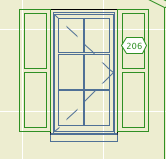
Wrong
(The way it should work: With the single click method and the pointer off, the label should be placed where the user clicked. This is one of those design issues that is so obvious I just call it a bug, opinions vary.)
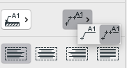
Here is my best compromise method. Turn the pointer on. Use the three-click geometry method. Put the first click anywhere on the opening. Put the second click level with the point where you want the label. (After this click the Y coordinate is set.) Put the third click precisely where you want the label.
Wrong, but be patient
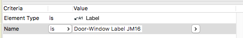
Label all the openings in the elevation. Use find and select to select all the labels by name.
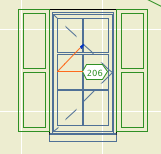
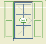
These ones
Turn the pointers off. The labels are off-center with the pointers on, but they will center on the third point with the pointers off.
Done
Much faster than adjusting each one.