
At the Sinclair gas station in Snowville, Utah, the one with the adorable dinosaur sculpture out front, where we stopped despite not needing gas because the next gas was 35 miles away, I told the kid that we were farther out in the middle of nowhere than she had ever been, and we were going *a lot* farther out. Google last streetviewed the main street of Snowville in 2008. The Sinclair dino wasn't there yet.
Starting in Twin Falls, ID, here are the kinds of roads we drove on: Four-lane interstate sometimes two-lane due to construction, two-lane state road, two-lane state road where they had just sprayed some black oil for maintenance and a helpful flagman said to stay in the left lane 'unless someone is coming the other way', Golden Spike National Historic Site parking lot, unmarked washboard gravel, sand, bad sand, grass alongside the bad sand, very bad sand flanked by shrubs so you have to drive on it even though you need a 4WD, shockingly bad sand around a corner uphill such that when you see it on the way back you won't believe you didn't get stuck this is where the faithful talk about miracles, grass blackened by fire alongside bad sand, OK firm sand, firm sandy grass, firm sandy grass with rocks, then larger rocks, then rocks that can't be overcome without a proper off-road vehicle.
I am telling myself the whole time that I have heard it was hard to get to, but this hard? On the washboard road I had seen a couple of ordinary cars going the other way, did they do this?
Then we are some distance from the site, but we don't know how far because my phone actually says 'No Service LOLOLOL'. Probably not three miles, but could be two. 'I think I see it, is that it?' Impossible to say because everything in the distance is in one plane, can't judge distance or contour. That shadowy thing could be something? I decide to run (I can run) up to this high bump on the shore where I hope to at least see how far away we are. The kid stays at the car. It's about a mile. I didn't have my Garmin. If I could have cleared those few big rocks we could have cruised.
The bump is the site and the shadowy thing is the work. There are a couple cars in the lot, and I talked to two people in a Kia that definitely didn't get over those rocks. As you have now guessed, we have outsmarted ourselves using Waze, and all you have to do is stay on the unmarked washboard gravel until you get here. So no, it's not impossible, just remote. Order is restored. Except I'm a running mile away from a car that has to re-cross the bad sand. Better look at the work in case I never regain the washboard gravel.
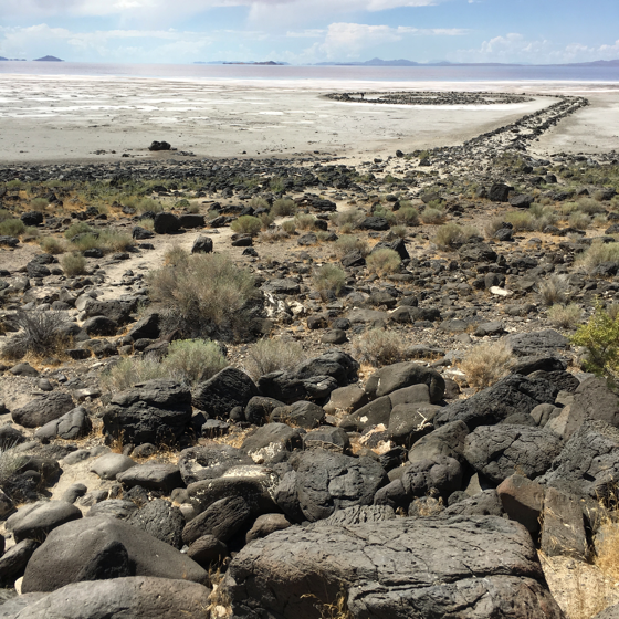
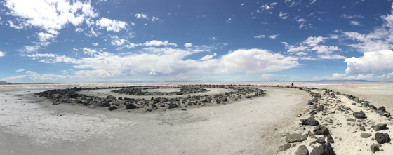
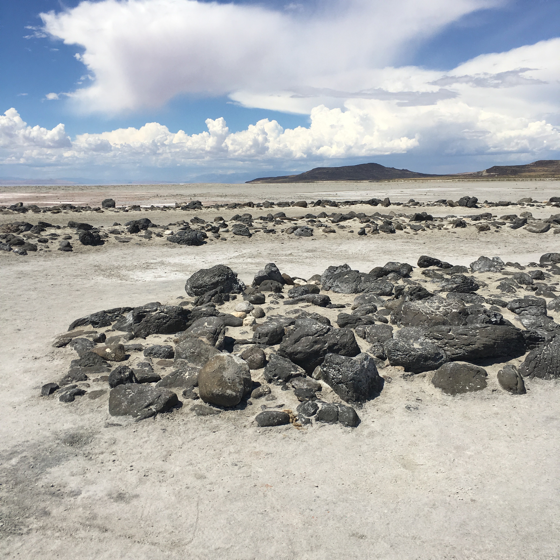
More than any other work I can think of, you have not seen this work as it appears to an in-person viewer. All of the well-known pictures are taken from the air, and offshore. The on site perspective is, relatively, nearly in plane with the work. It is probably smaller than you think, about the size of a house on a street, not monumental. And inches tall. The black rocks it is made of are the same as the ones blocking the car, and you have to climb down a shore of same rocks to reach it. The left and right edges of the jetty are taller/stronger, while in between it's black rocks embedded in soft beach sand. It is tedious to walk on - I shortcutted across to the center. Outside the jetty it is like pavement - hard flat salt in color ranging from snow white to red. The salt is salty, confirmed. Kudos if you walk the whole thing to the center.
Back to the car, where it took some doing to three-point around among the rocks we couldn't drive over, and out to the washboard, where I was never so happy to see a crappy unpaved road. Then we parked like civilized people, said hi to the Kia folks, and I saw the work for the second time, the kid for the first.
Somehow people have written in the salt-ground like it was wet sand, but they must have brought tools, because the local sticks don't cut it. I drew a very sketchy circle.
Several entire and partial skeletal remains of large birds. Swarms of flies here and there. Silence like we never hear except on heavy snowfall Sunday mornings, no, even silenter. I saw one plant, only because another visitor was photographing it.
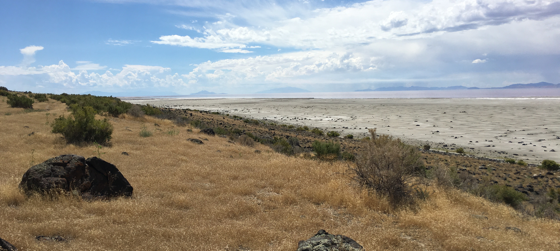
You can't walk to the 'shore' of the lake, though it is right there. The mucky ground begins just outside the work, and becomes gradually more mucky - you need boots. Just one of the ways I was city-mouse unprepared.
The rocks and sand of the jetty are completely clean of salt deposits, which are all over the surrounding ground. In most of the photos I have seen where the jetty is high and dry, the rocks are encrusted with salt. I hypothesize that it must have been some time since the rocks were submerged, and even the infrequent rain was enough to wash the salt away. The trend seems to be that the work will be on dry land for some time. I think it was built to be subtle, but it is high-contrast right now, at least when you are standing on it.
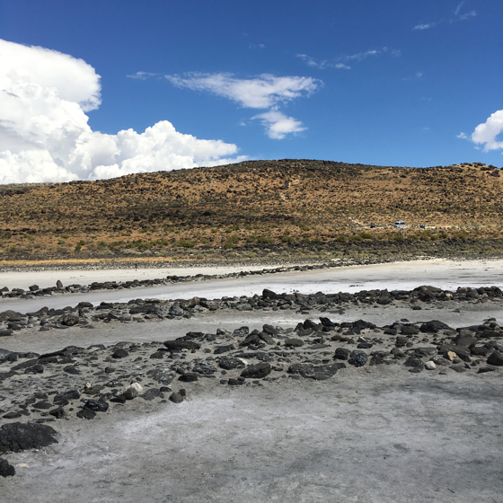
The most surprising part is how low-profile it is. The tallest rock is no more than two feet above the salt flat surroundings. So it's dry now, but two feet of water submerges it. 'Ideally', to have it dry but surrounded by water, the water would be about 8-16" deep, which seems incredibly tenuous and precise. OTOH, who cares about 'ideally'.
Promontory, UT, the nearest dot on the map, is not even a town, it's just the Golden Spike site. Apparently in 1869 in was a horrible den of iniquity on the newly completed railroad. Now it's nothing but they still oil the road up to the point it turns to gravel.

Then we drove to Salt Lake City, where the LDS have some amazing flower beds.