On Land

Environment Information
At Rill Architects we run ArchiCAD on macOS. If you work at Rill, this is your stuff. If you don't, but you work in ArchiCAD, you may find something interesting. Anybody else, I don't know.
RSS
December 2007 Archive
Sheet A3-2
The big difference between a building section and a wall section, besides the scale itself, is that the wall section has much more fine detail.

The additional detail of a wall section comes from (some) scale-sensitive model elements, along with 2D geometry and annotation placed in/around the modeled section. That's right, drawing. But this kind of drawing doesn't leave the model behind, and the section window remains live. In section, your modeling goal is an accurate 'envelope' of empty poché that looks clean at 1/4" scale, and can accommodate fine detail and annotation at wall section scale.

More»

Site plan fragment
What Shows

Note, November 10, 2017: Anywhere you see the layer +C Site Annotation, you can use the layer +C Site Note if the current project doesn't have the annotation layer. (This layer is quite new as of this update.) The difference is not important unless the site is being shared among multiple projects. If the site is shared, the annotations layer is for permanent data about the site, such as north direction, survey dims, and topo labels. Notes specific to the project go on +C Site Note.

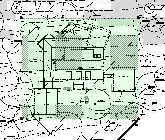
• General. The site plan is generated from the First Floor story. The 3D grade mesh is not shown because its pen and linetype options are too limited.

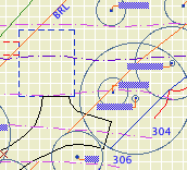
• Property boundary with metes and bounds. For the boundary, use an empty fill. (Only a fill can report its area, and you'll need the property area for the project information.) If north is set correctly and the boundary is precisely drawn, you can use and object for the metes and bounds, Survey Dim RND9, located in Graphic Symbols. Layers: C Site2 for the boundary, and +C Site Annotation for the text.

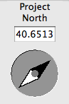
• North arrow object. North Arrow JAM9, located in Graphic Symbols. If north is set correctly, you can turn on the 'Use Project North' parameter. Layer: +C Site Annotation

• Setbacks. Layer: C Site2 Use lines, arcs, or polylines. Setbacks should be labeled 'BRL' (building restriction line). Special restrictions can be labeled more specifically; 'Conservation Easement', for example. Layers: C Site2 for the lines, and +C Site Annotation for the text.

• Topographic survey contours. If available. Use splines. Don't use lines, polylines or arcs. If you have lots of little segments, the dashed lines will never look right. Typically, we will get contours at two-foot intervals. The sea-level elevation of each contour should be called out, unless the contours are very closely spaced. In these cases, labeling only the ten-foot contours is OK. Layers: C Topo Existing and New for the splines, and +C Site Annotation for the text.

For boundary, setback, and topo text blocks, pay attention to the anchor point. This will help the blocks stay in position if you do multiple site plans at different scales.

• Building footprint. Layer: +C Footprint.N The footprint is the outline of the building as it meets grade. You will probably use the basement plan to get it. With the Site Plan layer combination active, show the A Wall Ext and S Wall2 layers. Trace the wall outlines with a polyline. You can show the basement story as trace (FKA ghost), or draw the polyline on the basement story and cut/paste it to the first floor.

Show dimensions from the footprint to the property boundary at key locations. For an addition project, the addition portion of the footprint should be filled with a diagonal pattern.

• Trees. If available. Use the object Tree JM10, located in 02 Site / Trees. Don't show removed trees unless you need to. Layers: L Tree2 or L Tree A. Trees on the 'A' layer will also show in the architectural plan. If you have modeled trees, you can place them on these layers or use L Tree3 to hide them in plans.

• Top view of building. This can be a roof plan or a 3D top view. This is a separate drawing overlaid on the site plan drawing.

• Additional building-related 2D elements. Anything you can't get to cooperate with the top view drawing can be drawn separately. Layer: +C House Line.

• Driveway. The layer L Drive2 shows in the site plan layer combinations. If you find that showing this driveway conflicts with the site plan somehow, you can modify the layer combination to hide it, and then redraw it with lines, arcs, and polylines on the C Site2 layer.

• Street. Layer: +C Site2 Use lines, arcs, or polylines.

• Notes. Label the major site and project elements. These are, at least, the existing house and addition, the driveway, pools, large terraces, septic fields. Layer: +C Site Note.

Line Types

• Boundary: Property Dot-dash
• Setbacks: BRL long dash
• 2' contour: Dense dashed
• 10' contour: Long Dashed
• Driveway and street: Solid
• Footprint: Dense Dashed

Fonts

The usual, but to review: Lucida Sans for notes. Tahoma for dimensions including boundary data. The street name looks nice with a serif font; use Times.

Top View Drawing
In the site plan, the top view of the house is a separate drawing.

Why? The site plan is generated from the first floor. The roofs are only seen in their entirety on the roof story. The only way to get the roofs on the first floor is to draw (trace, copy/paste, whatever) them. We don't like drawing things. Especially things that can draw themselves, especially things we have to keep checking in on to see if they are drawn properly. We want a top view drawing that maintains itself like any other model view.

There are two ways to do a top view so that it remains live: A plan view from the roof story (like the roof plan itself), or a hidden line top view generated in the 3D window. I think the 3D method is better. The 3D view can show elements of all stories, while the roof plan will use the story settings of individual elements. There's no issue of display order in 3D. A roof plan drawing would have the advantage of generating a little bit quicker, but that's not enough to change my mind.

The templates are set up with a view in the 3D views folder called 'Top View'. You might need to change the scale of this view; obviously it needs to match the scale of the main site plan. The other settings are:

• Layer combination: x Shoot Roof Plan Top View. (Update: I changed the name for clarity.)

• 3D Projection Settings: Top view, azimuth=270 (Camera at bottom).

• 3D Window Settings: Internal Engine, hidden line, vectorial hatching off, shadows off, transparency off.

The trickiest part about the two-drawing approach is aligning the top view with the main site plan. For some reason, we don't get the snap points (midpoints, e.g.) for lines within drawings, so we can't line up a roof edge midpoint with a footprint line midpoint. Fortunately, for most purposes, good enough is good enough. Zoom in and eyeball it. Make it look good. Remember, the dimensions will be to the footprint, which is drawn precisely in the main site plan drawing. If you do need a precisely placed top view, you'll need to place some temporary alignment elements on the first floor.

Make sure the top view's drawing element is set to have a transparent background. The pen set of thew drawing should be Layout 1/8", which turns the heavy lines a little less heavy.

Heads up concerning the issue date in the title block. I'm getting very erratic results when publishing; sometimes the title block drawing (on the master layout) updates automatically, sometimes it doesn't. If that drawing doesn't update, your title block data will be wrong, including the date.

I have confirmed that the drawings on the master layouts are set to auto update. That should be all it takes, but it's not.

For example, I changed the date and then published a PDF. The dates on the resulting PDF sheets are not changed. I immediately published again, without making any changes anywhere in the project. Now the title block is right.

Erratic.

The title block drawing will always update if you open its master layout. It seems it will also update if you open a regular layout. But I have seen cases where the layouts of some masters are updated but not others; it probably depends on what regular layouts have been opened.

But, each layout automatically opens as the publication happens! Yes, and it skips updating the master drawings. Sometimes.

Once again, we have an output-related, liability-hazardous, supposedly-automatic behavior where Archicad can't quite get the door all the way shut. And once again we have to follow it around making sure it's using its litter box.

My recommendation: If you are publishing anything where the date is critical (that's anything you're giving to anyone else), before publishing, open each master layout that is in use. Essentially, that's all the masters of a given size, just to be safe. Opening the master should trigger the auto update of the title block drawing, and then you should be set.

Date LOL

Sheet E1
What shows: Walls, stairs, counters, decks, appliances and mechanical equipment, and all electrical symbols.

More»

Isn't north up? Probably not. Since the orientation of the project is driven by the geometry of the plan, north can be any which way.

Project North
In the Sun dialog
The north direction for the project is set in the Sun dialog. You get there via the Sun button in the Camera settings box, or via the More Sun button in the 3D Window Settings dialog. MORE: Karl Ottenstein points out that you can also go directly to the Sun dialog by right-clicking on any 3D viewpoint (camera, axon, etc.) in the Project Map, or on any 3D view in the View Map.

Note: Though it's called 'Project' north, it's true north, in that it's the only north, and the north used by the sun settings. Archicad doesn't directly support a project north environment variable separate from true north.

There are at least four reasons to set project north correctly:

• Accurate sun shadows

• Automatic orientation of north arrow symbol objects.

• Automatic dimensioning of metes and bounds using the Survey Dim RND9 object.

• Correct naming of interior elevations with the Orientation autotext. (A real project north would be nice here.)

For the purposes of sun shadows and interior elevation names, you can eyeball the north direction by moving the pointer in the Sun dialog. A degree or two off isn't going to hurt.

For the metes and bounds to work, you need to set the direction exactly.

More»